
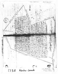
The 1738 Map of Rowley CanadaRowley Canada was granted in 1736 to John Tyler, Joseph Pike and fifty-nine others, either officers or soldiers in the Canada expedition of 1690, or descendants of those deceased. The grantees were nearly all from Rowley, Topsfield, Boxford and other towns in Essex County, Massachusetts, which were parts of the original town of Rowley. Among the grantees were some of the leading men of the time in public life of the Massachusetts colony. (History of the Town of Jaffrey, New Hampshire (1937) Vol I, p. 43.) It wasn't surveyed until 1738 and the Plat shown here is a result of that survey. The resulting polygon covered what are now portions of Jaffrey, Dublin, Peterborough, Sharon, New Ipswich and Rindge, as clearly seen in the Plan included here which appears on page 47 of the Town History (1937, Vol I). The following is a transcription of Heywood's survey: A Plat of a Tract of Land of the Contents of Six Miles Square laid out by Nathan Heywood Surveyor & Chainmen on Oath to Satisfie a Grant made by the Great & General Court of the Province of the Massachusetts Bay, held at Boston the 24th of Novemr 1736. to John Tyler, Joseph Pike & others, that were either Officers or Soldiers in the Canada Expedition Anno 1690, or the Descendts of Such of them as are Decd, which Tract lieth to the Southward of the Grand Monadnuck so called, & adjoining to the Township lately granted by Sd Court to Samll Haywood &c. Beginning at a Maple Tree the North Easterly [Westerly] Corner of Dorchester Canada Township from thence running North 32 Degr East two Miles & one Hundred poles to a Heap of Stones, Thence North 22 Degrs East four Miles, Thence North One Mile till it meets with the Sd Township granted to Samll Haywood &c; thence West four Miles by the Said Township to the South Westerly Corner thereof, thence North by the Said Township, Three Miles & 220 poles, thence West 20 Degrs South five Miles & 180 perch to a Wild Cherry Tree on the Southward of the Grand Monadnuck aforesd, Thence South One Thousand & eighty perch; Thence East 41 Degrs South Two Thousand five Hundred Perch, to a Heap of Stones Then North Twelve Deg; East one Mile to the Northeasterly Corner of Dorchester Canada Township being the Maple Tree first mentioned—With the allowance of One Rod in Thirty for uneven Land & Swag of Chain; And there is a further allowance within the Said Tract for Ten large ponds and a large Shrub Swamp about four Mile in Length & a Mile in Wedth- Examd & Approvd, Ebenr Burrill Source: History of the Town of Jaffrey, New Hampshire (1937) Vol I, p. 46. The whole subject of Rowley Canada is not always easy to follow. Click here to read the several pages devoted to it in the Town History. Click here to see how Rowley Canada is shown on Thos. Jeffreys map of 1768 (where it is called Rowley to Canada). |
 Click here to download and view a .pdf of A Plat of a Tract of Land of the Contents of Six Miles Square laid out by Nathan Heywood, Surveyor…(Rowley Canada) 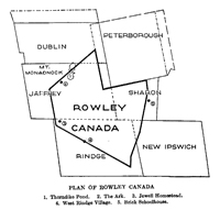 Click here to download and view a pdf of a descriptive version that appears in the History of Jaffrey, New Hampshire (1937) Vol I, p47.(Rowley Canada)
|