
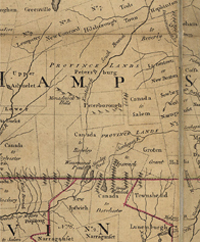
A Map of the Most Inhabited Part of New England… (Detail)This map first appeared in 1755 and was issued in many editions. It's full title is A Map of the most Inhabited part of New England, containing the Provinces of Massachusetts Bay and New Hampshire, with the Colonies of Connecticut and Rhode Island, Divided into Counties and Townships; The whole composed from Actual Surveys and its Situation adjusted by Astronomical Observations. The detail included here shows Canada to Rowley as a irregular polygon bounded by Peterborough, Canada to Dorchester and Province Lands. It included parts of present-day Jaffrey, Dublin, Sharon, Rindge and New Ipswich. Monadnock is referred to as 'Monadnock Hills' and the Contoocook River appears as Kontakook. |
 Click here to download and view a pdf of a portion of the 1768 A Map of the Most Inhabited Part of New England…(Jeffreys).  Click here to download and view a pdf of the title block of the 1768 A Map of the Most Inhabited Part of New England…(Jeffreys).
|