Maps > 2008 Zoning Map
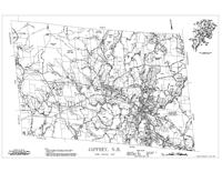
Jaffrey Zoning MapThis map of Jaffrey is the current Town Base Map with Zoning Districts added. It was first produced in 1993 with this revised version appearing on April 1, 2008. Shown are streets and highways, ponds, lakes and wetlands, rivers and streams, lot boundaries, utility easements, and zoning districts. In the upper right corner is as a "detail showing road names in Jaffrey village." |
Click here to download and view a pdf of the Jaffrey Zoning Map (2008). |