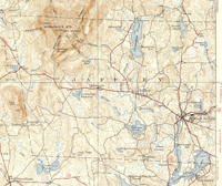
1936 U.S.G.S. Monadnock Quandrangle
This map of Jaffrey was taken from the 1936 USGS Monadnock quadrangle. This was not combined with the Jaffrey portion of the Peterboro quadrangle as no quadrangle of a comparable date was published. (Peterboro sheets were published in 1900 and 1953 only.)
1) Monadnock New Hampshire
USGS 15 minute series.
Surveyed 1932.
Topography by A.J. Ogle, W.K. McKinley, R.M. Wilson, E.V. Holloway, C.S. Maltby, and Shirley Waggener.
Culture and drainage in part compiled from aerial photographs taken by Air Corps, U.S. Army.
Edition of 1936
Scale: 1:62,500.
Contour interval: 20 feet.
|
| Title: |
USGS Monadnock quadrangle |
| Compiler: |
USGS |
| Date: |
1936 |
| Place: |
Washington, D.C. |
| Publisher: |
U.S. Geological Survey |
| Scale: |
1:62,500 |
| Size: |
21-1/2 x 18 inches. |
| Notes: |
See to the left. |
Click here to download and view a pdf of a portion of the 1936 USGS Monadnock quadrangle.
Two sources for historical USGS maps of New Hampshire or other New England states are Maptech and the University of New Hampshire.
|