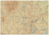
Made-Up Topographic Map of Jaffrey
This 'made-up' map of Jaffrey was produced by JaffreyHistory.org by combining sections of two maps resulting in a single map of Jaffrey, this being because the coverage for Jaffrey is split by the two maps. The two maps in questions are:
1) Monadnock New Hampshire
USGS 15 minute series.
Surveyed 1887 and 1895. Topography by H.L. Smyth (1887) and Jas. McCormick (1895).
Published May 1898, reprinted 1918.
Scale: 1:62,500.
Contour interval: 20 feet.
2) Peterboro New Hampshire
USGS 15 minute series.
Surveyed 1897. Topography by R.D. Cummin and N.G. Van Doren.
Engraved Dec. 1899.
Published June 1900, reprinted 1937.
Scale: 1:62,500.
Contour interval: 20 feet.
|
| Title: |
Made-up topographic map of Jaffrey, N.H. |
| Compiler: |
USGS |
| Date: |
1898 and 1900 |
| Place: |
Washington, D.C. |
| Publisher: |
US Geological Survey |
| Scale: |
:62,500 |
| Size: |
The two sheets are each 21-1/2 x 18 inches. |
| Notes: |
See to the left. |
Click here to download and view a pdf of the 1898-1900 topographic map of Jaffrey.
Two sources for historical USGS maps of New Hampshire or other New England states are Maptech and the University of New Hampshire.
|