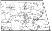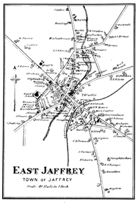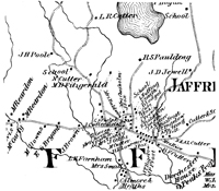
1877 Atlast of Cheshire CountyTe Atlas of Cheshire County contains two maps of Jaffrey: One covers the entire town and the other is a detail of East Jaffrey, now Downtown Jaffrey. The 1877 Atlas of Cheshire County is a fascinating and valuable document of unusual origin. Published at the time of the nation's centennial, it captures our region in transition. The traditional farm economy, clearly visible here in page after page of rural lanes weaving among scattered homesteads, was declining before the powerful new forces of railroads and industry. Keene, then at the junction of three rail lines, had doubled in population in one generation, while nearby Stoddard, without rail service, declined by more than one-third. The expanding industrial marketplace supported numerous mills, small businesses, and quarries, all shown here with the owners' names. Cheshire County is fortunate to have had historical map coverage three times in five decades. The 1877 atlas was preceded by the 1858 Map of Cheshire County, a large wall map, which undoubtedly served as the primary source for the present work. At the end of the century, a state atlas mapped a further changed cultural landscape.(1) Whereas all ten New Hampshire counties were represented by wall maps in the 1850s and 1860s, and by the 1892 state atlas, only Cheshire County and one other (Strafford in 1871) were fortunate enough to have been mapped in the middle of that transitional period. Nineteenth century mapmaking was a private commercial enterprise dominated by firms in Boston, New York, and Philadelphia. Most of the populous counties in the United States were documented on maps and atlases in the latter half of the century. During the 1850s, these companies produced hundreds of large wall maps which plotted—in many cases for the first time—all the roads and homesteads in the various counties. A decade later, map publishers turned to the atlas format. The atlases were more compact, and allowed inclusion of more data. They were usually sold in advance by agents who would ride house-to-house by horse and buggy recording the names of current homeowners, as well as soliciting subscriptions. The publishers often augmented their subscription revenue by selling space in atlases for business advertisements, personal portraits, and biographies.(2) The 1877 Atlas of Cheshire County is a comparatively rare document today, whose existence has not been widely known. Its scarcity might be explained by the poor economic conditions of the mid-1870s. There was a financial "panic" in 1873, with an ensuing agricultural depression which affected much of rural America. The pages of the New Hampshire Sentinel (a weekly Keene newspaper) list many farms for sale and make reference to numbers of "tramps" in the region.(3) It is likely that Comstock and Cline, the publishers of the Cheshire County atlas, did poorly with their advance sales, and printed only as many atlases as they needed. The Cheshire County atlas is related to another seldom-seen work, also published by Comstock and Cline, the Atlas of the State of New Hampshire of 1877. Copyright records indicate that the state atlas preceded the county publication by a few months. The county atlas has the identical Business Directory; its general maps (United States, New Hampshire and Vermont, and Cheshire County topographical) are the same as those in the state atlas.(4) The latter, however, includes topographic maps of all of the counties in New Hampshire, as well as street maps of cities (on which only public buildings are labeled). It has no detailed property ownership maps at all. The state atlas also differs from the Cheshire County atlas in having many pages of text on geology, climatology, forest resources and the like. Of the ten New Hampshire counties, only Cheshire received a separate 1877 atlas. Why? Was it a "reward" for the substantial patronage of the state atlas by local residents? (One of every four listings in the "business directory" is from Cheshire County.) Did C. H. Rockwood, the "superintendent" of this project, have some attachment to the area, and thus commit himself to a venture which more commercially-minded mapmakers would not undertake? Whatever its provenance, the Atlas of Cheshire County is a charming blend of professional and amateur cartography. A number of unusual characteristics stand out. The convention of placing "north" at the top of the page is ignored on some maps, making them difficult to read at first glance. Scale is nowhere indicated for most of the town maps (it is approximately 1-1/4 inches to the mile). The lettering style in the title blocks varies, and every compass arrow (there are fourteen in the original) is of a different design! While the Cheshire County atlas does have a "business directory," it lacks the portraits and biographical sketches which helped to build profits for other atlases. The atlas even contradicts itself: the elevation of Mt. Monadnock, the county landmark, is described at 3718 feet in the historical sketches, and more accurately depicted as 3100 feet on the topographic map. Most unfortunately, two entire villages are omitted—Alstead and Chesterfield Factory (Spofford). These deficiencies and curiosities should not obscure its value. The Atlas of Cheshire County is filled with historical data which would otherwise be unavailable. It locates farmsteads and businesses in a time of rapid change. It presents the first topographic map of our region, showing elevations of hills and valleys in 100 foot contour intervals.(5) The Railroad Map of the United States shows the growth of the remarkable transportation system that was changing Cheshire County and the nation. Data on population and on library holdings help paint a picture of the times against a backdrop of historical sketches and "firsts" (first settlement, tavern, church, birth, etc.). We see our forebears applying themselves to the resources available to them. Although grist, saw, and woodworking mills predominate, there are textile mills in half the towns of the region, showing the diversification of the local economy. Granite quarries and a gold mine produced minerals whose markets were far removed from the county boundaries. Some entries are less obvious: the palm leaf shop in Winchester, the plumbago mine in Nelson. What were the "Moscow beavers" made by M. Collins in Harrisville? This new edition of the Atlas of Cheshire County employs a different format from the original, but in no case have textual details been altered. Fidelity to the substance of the original has been our primary concern. The original atlas is a hardbound volume measuring 15 inches by 17-1/2 inches, whereas the present is softbound and smaller in size. To preserve the scale of the maps, their layout has been rearranged. In the original atlas most of the town maps are printed in groups across the large double pages, with village detail maps filling the margins. This procedure resulted in as many as nine maps appearing on a set of facing pages. In the 1982 edition, most town maps are on single pages (with added line borders), and no more than four maps occupy a page spread. Many of the original maps are tinted; we have not reproduced the color. Compass arrows have been added, where necessary, to eliminate confusion.(6) Where none appears, north is at the top. Some title blocks have been repositioned for ease of reading. Pages 16 and 30 are vacant because of the omission of the villages of Alstead and Chesterfield Factory from the original. To conform to the present format, the three general maps (pages 6-11) and the Keene detail map (pages 22-23) have been reduced. Abbreviations used on these maps include: P.O., post office; GM, grist mill; SM, sawmill; SSM, steam saw mill; BSS, black smith shop. The rod, a bygone unit of measurement, is equivalent to 16-1/2 feet. Publication of this volume likely marks the first time, in this century or the last, that this material has seen wide circulation. We have accurately reproduced everything in the original Atlas of Cheshire County, and it is our hope that this new edition will stimulate further interest in the history of our region. (1) Town and City Atlas of the State of New Hampshire (Boston: D.H. Hurd & Co., 1892). (2) Drawn from Norman J. Thrower, "The County Atlas of the United States," in Surveying and Mapping, Vol. 21 (Sept. 1961), 365-373; and Walter W. Ristow, Maps for an Emerging Nation: Commercial Cartography in Nineteenth Century America (Washington, D.C.: Library of Congress, 1977). (3) New Hampshire Sentinel, Dec. 10, 1875, and Aug. 24, 1876. (4) Some copies of the N. H. state atlas have the Cheshire County map pages bound within. The page enumeration, 77-a, b, c, etc. suggests a "Cheshire County issue" of the state atlas. (5) Scientific mapping of the state was begun in the 1860s by the U.S. Coast Survey, but the official government maps were not printed until much later. Thoreau, in his Journal (Aug. 6, 1860) noted the surveyors atop Mt. Monadnock signalling with mirrors toward Laconia. (6) The symbol used in these cases is [a graphic north arrow not included here]. SOURCE: [Allen, David]. Atlas of Cheshire County New Hampshire from Recent and Actual Surveys & Records (Reproduction issued by Old Maps, West Chesterfield, NH, 1982). |
Click here to download and view a pdf of the Jaffrey portion of the 1877 Atlas of Cheshire County.
Click here to download and view a pdf of the East Jaffrey portion of the 1877 Atlas of Cheshire County.
Click here to download and view a pdf of the Jaffrey Center portion of the 1877 Atlas of Cheshire County. |